Heritage, Volume 12, Number 2, Spring 1994 Page: 13
30 p. : ill. ; 28 cm.View a full description of this periodical.
Extracted Text
The following text was automatically extracted from the image on this page using optical character recognition software:
Shortly after meeting at the Hernandez
Cemetery, I was hired as an assistant professor
to teach archaeology at Texas Tech
University. Three years went by and during
the summers I established an archaeological
field school in the San Saba region of
Texas. I chose this area for our schools
mainly because of my long-term research
interests in use of native pecans as a food
resource by prehistoric people in Texas.
The San Saba River has extensive groves of
native pecans growing along its banks. I
have thus been spending six weeks each
summer camped with my students in a
pecan grove along the San Saba as we learn
the methods and techniques of field archaeology.
I n the meantime, Mark and Kay
had renewed their acquaintance, and Mark
told Kay of his interest in Mission Santa
Cruz de San Saba stemming from recent
study of his genealogy. He was surprised to
learn that the mission had not been found,
in spite of the fact that the nearby presidio
was evident and had played a crucial role
in the founding of Menardville, now
known as Menard. Fired by a fascination
with his own ancestry and the challenge of
discovery, Mark set out to find the mission.
He asked Kay Hindes to help him with the
search.
From studying Shawn Carlson's "The
Search for San Saba", an earlier mission
investigation funded by the Texas Historical
Foundation, Mark and Kay knew that
traditional search methods had proved inadequate.
They followed one of the report's
recommendations calling for application
of aerial remote sensing techniques in the
search for the mission. During the spring of
1993, Kay, Mark, and Mark's pilot friend
Glynn Crain made a couple of reconnaissance
flights over some land east of Menard
that they had targeted as the most likely
area for the mission to be located. The
group used color-, infrared-, and blackand-white
films in their cameras in hopes
that at least one of these film types would
be sensitive to ground patterns diagnostic
of the mission. Mark and Kay had their
film developed and began inspecting the
images for telltale signs. A big rectangle
was identified by shadowy alignments
visible in an alfalfa field owned by Jerry
Rambo. Mark guessed the rectangle might
be appropriate for the log stockade known
to have been erected around the mission to
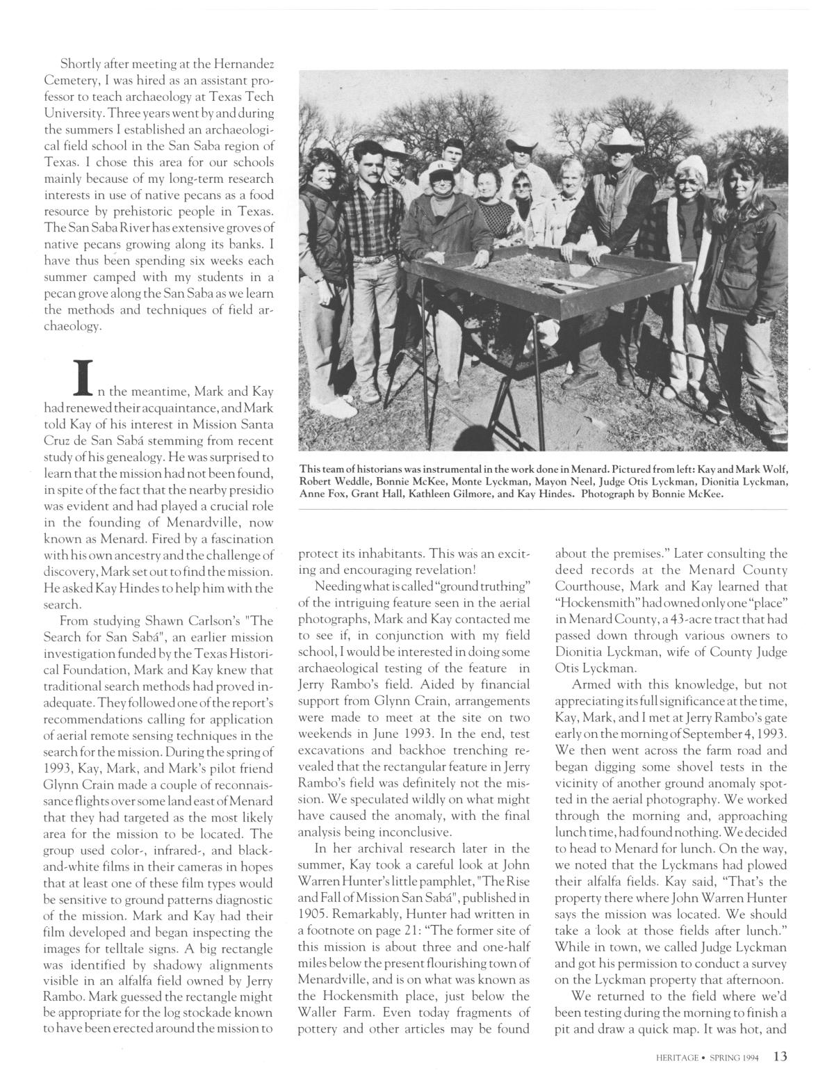
This team of historians was instrumental in the work done in Menard. Pictured from left: Kay and Mark Wolf,
Robert Weddle, Bonnie McKee, Monte Lyckman, Mayon Neel, Judge Otis Lyckman, Dionitia Lyckman,
Anne Fox, Grant Hall, Kathleen Gilmore, and Kay Hindes. Photograph by Bonnie McKee.
protect its inhabitants. This was an exciting
and encouraging revelation!
Needing what is called "ground truthing"
of the intriguing feature seen in the aerial
photographs, Mark and Kay contacted me
to see if, in conjunction with my field
school, I would be interested in doing some
archaeological testing of the feature in
Jerry Rambo's field. Aided by financial
support from Glynn Crain, arrangements
were made to meet at the site on two
weekends in June 1993. In the end, test
excavations and backhoe trenching revealed
that the rectangular feature in Jerry
Rambo's field was definitely not the mission.
We speculated wildly on what might
have caused the anomaly, with the final
analysis being inconclusive.
In her archival research later in the
summer, Kay took a careful look at John
Warren Hunter's little pamphlet, "The Rise
and Fall of Mission San Saba", published in
1905. Remarkably, Hunter had written in
a footnote on page 21: "The former site of
this mission is about three and one-half
miles below the present flourishing town of
Menardville, and is on what was known as
the Hockensmith place, just below the
Waller Farm. Even today fragments of
pottery and other articles may be found
about the premises." Later consulting the
deed records at the Menard County
Courthouse, Mark and Kay learned that
"Hockensmith" had owned only one "place"
in Menard County, a 43-acre tract that had
passed down through various owners to
Dionitia Lyckman, wife of County Judge
Otis Lyckman.
Armed with this knowledge, but not
appreciating its full significance at the time,
Kay, Mark, and I met at Jerry Rambo's gate
early on the morning of September 4, 1993.
We then went across the farm road and
began digging some shovel tests in the
vicinity of another ground anomaly spotted
in the aerial photography. We worked
through the morning and, approaching
lunch time, had found nothing. We decided
to head to Menard for lunch. On the way,
we noted that the Lyckmans had plowed
their alfalfa fields. Kay said, "That's the
property there where John Warren Hunter
says the mission was located. We should
take a -look at those fields after lunch."
While in town, we called Judge Lyckman
and got his permission to conduct a survey
on the Lyckman property that afternoon.
We returned to the field where we'd
been testing during the morning to finish a
pit and draw a quick map. It was hot, and
HERITAGE * SPRING 199413
Upcoming Pages
Here’s what’s next.
 14 of 32
15 of 32
16 of 32
17 of 32
14 of 32
15 of 32
16 of 32
17 of 32
Search Inside
This issue can be searched. Note: Results may vary based on the legibility of text within the document.
Tools / Downloads
Get a copy of this page or view the extracted text.
Citing and Sharing
Basic information for referencing this web page. We also provide extended guidance on usage rights, references, copying or embedding.
Reference the current page of this Periodical.
Texas Historical Foundation. Heritage, Volume 12, Number 2, Spring 1994, periodical, Spring 1994; Austin, Texas. (https://texashistory.unt.edu/ark:/67531/metapth45413/m1/13/: accessed April 25, 2024), University of North Texas Libraries, The Portal to Texas History, https://texashistory.unt.edu; crediting Texas Historical Foundation.