The Southwestern Historical Quarterly, Volume 87, July 1983 - April, 1984 Page: 152
468 p. : ill. (some col.), maps (some col.), ports. ; 23 cm.View a full description of this periodical.
Extracted Text
The following text was automatically extracted from the image on this page using optical character recognition software:
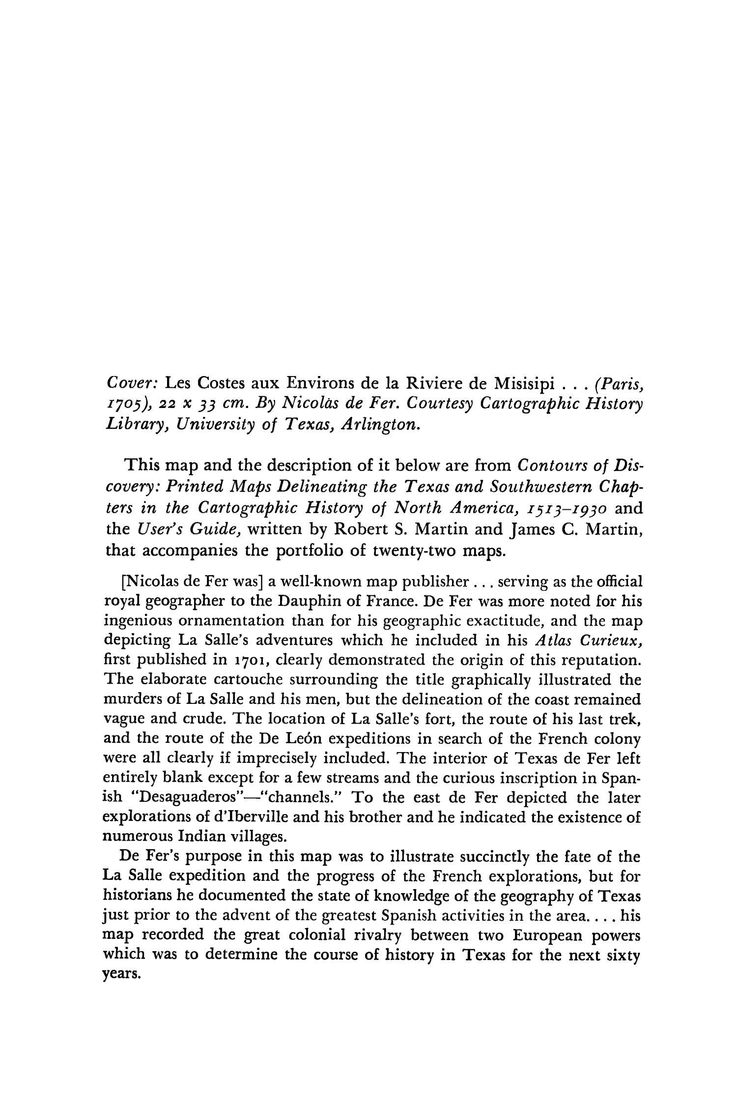
                                Cover: Les Costes aux Environs de la Riviere de Misisipi . . . (Paris,
1705), 22 x 33 cm. By Nicolas de Fer. Courtesy Cartographic History
Library, University of Texas, Arlington.
This map and the description of it below are from Contours of Dis-
covery: Printed Maps Delineating the Texas and Southwestern Chap-
ters in the Cartographic History of North America, 1513-193o and
the User's Guide, written by Robert S. Martin and James C. Martin,
that accompanies the portfolio of twenty-two maps.
[Nicolas de Fer was] a well-known map publisher ... serving as the official
royal geographer to the Dauphin of France. De Fer was more noted for his
ingenious ornamentation than for his geographic exactitude, and the map
depicting La Salle's adventures which he included in his Atlas Curieux,
first published in 1701, clearly demonstrated the origin of this reputation.
The elaborate cartouche surrounding the title graphically illustrated the
murders of La Salle and his men, but the delineation of the coast remained
vague and crude. The location of La Salle's fort, the route of his last trek,
and the route of the De Le6n expeditions in search of the French colony
were all clearly if imprecisely included. The interior of Texas de Fer left
entirely blank except for a few streams and the curious inscription in Span-
ish "Desaguaderos"-"channels." To the east de Fer depicted the later
explorations of d'Iberville and his brother and he indicated the existence of
numerous Indian villages.
De Fer's purpose in this map was to illustrate succinctly the fate of the
La Salle expedition and the progress of the French explorations, but for
historians he documented the state of knowledge of the geography of Texas
just prior to the advent of the greatest Spanish activities in the area . . . his
map recorded the great colonial rivalry between two European powers
which was to determine the course of history in Texas for the next sixty
years.
Upcoming Pages
Here’s what’s next.
 153 of 543
154 of 543
155 of 543
156 of 543
153 of 543
154 of 543
155 of 543
156 of 543
Search Inside
This issue can be searched. Note: Results may vary based on the legibility of text within the document.
Tools / Downloads
Get a copy of this page or view the extracted text.
Citing and Sharing
Basic information for referencing this web page. We also provide extended guidance on usage rights, references, copying or embedding.
Reference the current page of this Periodical.
Texas State Historical Association. The Southwestern Historical Quarterly, Volume 87, July 1983 - April, 1984, periodical, 1983/1984; Austin, Texas. (https://texashistory.unt.edu/ark:/67531/metapth117150/m1/152/: accessed April 18, 2024), University of North Texas Libraries, The Portal to Texas History, https://texashistory.unt.edu; crediting Texas State Historical Association.